Abstract
The Nun River Basin (NRB) has a long history of cross-border conflicts, mostly connected to the impact of climate change on water sources and resources. This article discusses the link between water politics and conflicts among the traditional communities in the NRB. Water scarcity and floods have led to border conflicts among the “traditional states” at the drier edges and in the marshes of the NRB. Initial mappings to determine geopolitical and water security contexts helped identify the areas, including firstly, Bamali, Bamunka, Babungo and Baba I, with maritime border conflicts, and secondly the Babessi and Baba I floods, with access in the NRB. Based on our findings and analysis of existing sources and critical interviews, the recognised and unrecognised links that bind water to the regional politics and relations among the fondoms are central to the conflicts related to the control of water sources and the fertile rice cultivation marshes. The article concludes that although the “traditional states” have been in mutual competition, where food needs accelerate in response to rising populations and economic interest, the traditional method of conflict resolution through consensus has been most effective in achieving peace in the region.
1. Introduction
Hydropolitics relating to trans-border water areas and conflicts caused by climate change are a huge challenge for Africa, with more African traditional communities and non-state actors gaining interests in the competition for the control of water sources and resources in the face of the effects of climate change. The “Anglophone War”, which began in 2016 and is still running, is the most recent conflict in the English-speaking part of Cameroon – including the Nun River Basin (NRB). This war adds to the existing conflict-riddled environment marked by inter-tribal skirmishes relating to the control of water sources and wars of territorial expansion in the rich agricultural marshes of the NRB. The NRB includes the “traditional states” of Bamessing, Bamali, Bafanji, Bambalang, Bamukumbit, Balikumbat, Bamunka, Babungo, Baba I, Babessi, and Bagolan (Chilver and Kaberry 1966:21). They are located on the Ndop Plain of the Ngoketunjia Division of northwestern Cameroon. With a population of 187 348 inhabitants (BUCERP Report 2005:59), 80 per cent of whom are economically dependent on agriculture, this region is highly vulnerable to the impacts of climate change – mainly conflicts and floods. These impacts compound many of the region’s social, political and economic challenges. They have worsened livelihood conditions accelerated recently by the “Anglophone War”, which has already resulted in increased migration and displacement. These are domestic and trans-border risks, and add to the probability of political tensions and violent conflict within and among these “states”.
This article examines the row among the riparian “traditional states” of the NRB. It examines the respective claims and measures taken to resolve the disputes and the geopolitical and strategic significance of the row. It also highlights the role of a corporate actor, the Upper Nun Valley Development Authority (UNVDA), and other factors such as the construction of the Baminjin Dam on the Nun River. But water is more than a source of electrical power and a basis for agriculture and livelihoods. This article investigates a range of interactions among riparian traditional communities and geopolitical arrangements. The interest of the article expands to the complexities and opportunities offered in relation to conflicts, coexistence and cooperation among the riparian “traditional states” of the NRB. It is but a beginning, a beginning at a time of significant institutional, technological and climatic changes, which have consequences for the future of hydropolitics in the NRB and all other water basins in Cameroon. Regarding the geopolitical history of water, this article provides a more comprehensive approach as it illustrates the political dimensions and complex interactions of trans-border waters by highlighting the geopolitical overlay of the hydropolitics of the NRB. The NRB is divided by political borders, with asymmetric and inter-dependent socio-economic relations among the riparian “traditional states”, and is associated with non-integrated management and a lack of cooperation.
The unilateral utilisation of the Nun River by these riparian “traditional states” (drier edges upstream and wet marshes downstream), without entirely respecting all water rights in the basin, is a cause for concern for the whole sub-region. The principles of “Equitable and reasonable utilisation” along with the “No harm obligation” (the main concepts in Articles 5 and 7 of the 1997 UN Water Courses Convention), and of Integrated Water Resources Management (IWRM), are ignored. In this regard, individual, collective and corporate rice farming require a hydraulic measure to control water resources.
This article concludes by arguing that the control and capture of water resources in the NRB does not serve economic development interests alone, but also more broadly represents the geopolitical interests of the concerned parties – particularly those of the corporate actor (UNVDA). Water is highly politicised under such conditions. Therefore, the corporate actor’s strategies involve controlling water resources for its own interests and ignoring the basin’s integrated approach for serving all riparian communities’ water demands. These strategies ultimately threaten the process of peace-building and the creation of a mutual understanding among the riparian “traditional states” along the basin, considering that large rice-cultivated areas can provide the owner with the political hegemony and legal power to strengthen its position in future negotiations about water allocation. Without trilateral negotiations and agreements, Bamunka on the one hand, and Babungo, Bamali and Baba I on the other, have sought to unilaterally establish their rights to access water and to control the rules of the game by changing the asymmetric power relations.
“Traditional states”, as conceived in this article, underscore the independence and autonomy enjoyed by the kingdoms located in the NRB. These “traditional states” have functional authority governance systems with political and governance institutions, which are headed by the Fon or Chief (Kungso 2019:78). Going by the Bamenda Grassfields (north-west Cameroon) parlance, the leaders are called Fons, and the territorial and geographical entity is referred to as a Fondom or Chiefdom. These concepts have been used interchangeably in this article.
This article comprises three sections. The first section conceptualises water politics and development in the NRB. The article then sketches the hydrological and socio-economic context of the NRB and its main characteristics. The second section presents the “traditional states” and explains the institutional history of trans-boundary water interactions in the basin. Through a critical hydropolitical analysis, the penultimate section considers the geopolitics of water and the potential for conflict in the sub-region. Finally, the last section addresses the series of skirmishes that led to full-blown inter-tribal wars and how external powers’ strategies thwart the peace-building process and the creation of a mutual understanding in the basin.
2. Geopolitical overview of the Nun River Basin
2.1 Location of the Nun River Basin
The Nun River Basin on the Ndop plain, along the Bamenda-Kumbo Highway, is the area under study in north-west Cameroon. It comprises 13 fondoms, Babungo, Baba I, Babessi and Bangolan, chiefdoms that make up the Babessi sub-division, Bamunka, Bamali, Bambalang, and Bamessing which constitute the Ndop sub-division, and Balikumbat, Bafanji, Bamunkumbit, Bali Gashu and Bali Gansin making up the Balikumbat sub-division – all of which make up the Ngoketunjia Division (N.A.B. File No 1273/1951, Gazetteer of Place Names 1951:1). The NRB shares common boundaries with fondoms in the Bui, Boyo and Mezam Divisions. The basin is estimated to have an area of 4000 km2 and sustains a population of 187 348 inhabitants, 70 per cent of whom are involved in activities such as agriculture, fishing, grazing, hunting and gathering (Neba 1999). It is one of the major bread baskets of Cameroon in terms of its agricultural outputs, which are exported to the main urban centres of the country. The average altitude here is 1200 m; the lowest and marshy areas are however 900 m above sea level.
It is situated between 5°37’ and 6°14’ N and between 10°23’ and 10°33’ E (Neba 1999).
Figure 1: The hydrographical network of the Nun River Basin
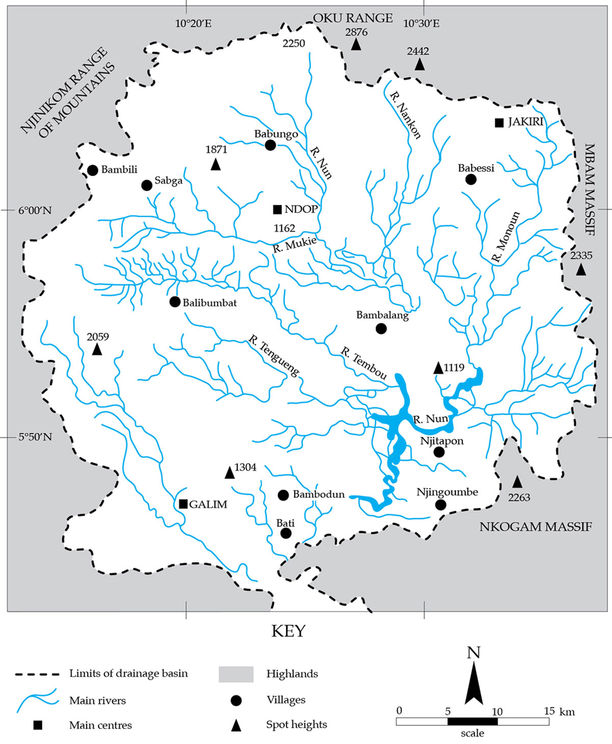
The NRB has undulating hills, but a greater part consists of lowlands which form part of the Ndop Plain – most of which is covered by swamps. Erosion influenced the relief of the area by creating gullies which later become valleys. These relief features are important water sources from which numerous streams, that flow across the basin, arose (Ngwa 1982:61). These slopes and valleys are sometimes filled with water along the banks of major rivers. The area presents two distinct relief features: the rocky north and muddy plains of the south. These slopes are fairly accessible by road. The steep slopes stretch from the extreme north-west to the north-east (Ngwa 1982:42). The rainy season lasts for over eight months and the dry season for over four months. The NRB has numerous streams such as the Phebeuh, Meyheo and Meneh. Other major streams are the Moufou, which combines downstream with the Meneh to form the River Messi (Ngwa 1982:42). These streams are an important tributary of the Nun River. They flow with high velocity at their sources and with low velocity over the plain. Though seasonal, these streams maintain a considerable flow volume during the dry season. The NRB has large and extensive marshes which are located in the south and south-east, extending right to the shores of the River Nun (Neba 1999:53). A combination of these factors favours agricultural practices in this region.
2.2 The establishment of the “traditional states” (the era of coexistence and cooperation)
The excellent geographical environment of the Ndop Plain motivated the migration and settlement of fondoms of different origins into the area. At the same time, the internal dynamics of political struggles and of social and economic competition account for the dispersion of people over a wide area – in some cases as founders of new polities. The external dynamics imposed by the globalising influences of European colonisation and the nation-building processes introduced new concepts in the processes of the historical reconstruction of these fondoms (Kungso 2019). This saw the emergence of traditional-authority governance systems with new power structures and institutions that controlled the traditional political system of the “traditional state”. Thus, traditional governance was also an important aspect that the founders of these polities considered during the construction of the traditional authority system.
Almost all of the 13 “traditional states” in the NRB claim a Tikar origin, with the exception of the Ngemba and Chamba fondoms (Godwill Kungso 2019:32). The Fondoms of the Nun Basin extend beyond the drier edges at the foot of the northern ranges and hills intersected by the Nun River and its tributary. Apart from the Bali-Chamba and Ngemba chiefdoms, seven independent polities claim an Ndobo origin. These are Babungo, Baba I, Babessi (Bamessi), Bamessing, Bambalang, Bangolan and Bamunka (Munka). The origin of these fondoms from Ndobo is not in dispute, but the migration of most of them (except for the Babungo Fondom) as refugee fondoms from Bamum, forced them to cross the Nun River before settling at their present sites (Tita Ntuchu, personal communication 2001). The terms Tikar or Ndobo, as applied to the NRB polities, imply a claim to the legitimacy of political institutions and to their ultimate derivation from a legendary centre which sanctioned their adoption. The terms have neither ethnic nor linguistic connotations (Nkwi 1976:91). The traditional authority systems in this region have also built institutions managed by different types of leaders, who have given expression to the fundamental principles of democracy, checks and balances, the balance of power and values that underpinned the traditional socio-political organisation and governance (Kungso 2019:65).
The political undertone and indispensability of water to the functioning of the traditional authority systems of the basin require emphasis, as each “traditional state” jealously preserves and controls its water sources and flowing rivers. In the construction of the traditional authority systems in these fondoms, the physical environment played an indispensable role in the creation of the “traditional states”. The custom and tradition of Babungo, for example, is strongly connected to myths and water (Tita Tisah, personal communication 1997). The people believe that the ancestral god (Nwi) of Forghai (a waterfall) offered a black sheep which guided and instructed their ancestors to the area that the Babungo people now occupy (Kungso 2013). The waterfall at Forghai is an essential element in the history of origin and also the source from which traditional institutions of governance in Babungo have emanated. The relevance of the waterfall to the traditional political institutions was highlighted by Fon Zofoa II of Babungo in the following words: “One traditional bag containing a rope which was brought by the first people who came from Ndop in the Bamun Division. The place where they first settle was at small waterfall called Foghai, between Baba I and Babungo village … The ancestor Sorgho was asked to go and collect the fire. When he went there he was given it, and in addition his ancestor was given this bag by the god of that waterfall called Foghai, that it was a type of juju for the village to be playing it.” (Kometa Soteh, personal communication 2011).
The traditional bag was one of the traditional institutions known as Nguu. The last two elements of the waterfall are the fire and the black sheep. The custom and tradition of the Babungo considered the fire to be the light and the black sheep, a guide of the Babungo people – leading to the present site of occupation (Tita Sorgho, personal communication 2011). Another important river site which inhabits Nwi Dong found in Babungo (Shikau quarter) is a small pool of water that was considered to be the source of inspiration and life. Lastly, there is Begh, a waterfall in Babungo (Finkwi quarters) (Emmanuel Nchuo Minkee, personal communication August 2011). Weei Nwi Begh, the god of this waterfall, sent some special magical jujus known as Menai, which fought alongside the Babungo people to defeat their enemies during inter-tribal wars. These rivers are sites where important rituals are performed by the traditional institutions (Kungso 2013:73).
The question of land and space were very determinant issues, as the spatial occupation of land by the Fons reflected their personality and influence in the chiefdoms. All lands in the “traditional states” were owned and controlled by the Fons. The large, marshy lands were cared for by notables appointed to represent the Fons and to protect from any invasion by neighbours. The Fons received royalties from these places at the end of each harvesting season. Land use and special occupation soon became determinant factors in animating geopolitical discussions and igniting the hydro conflicts in the NRB.
The economy of the basin was dominated by bush fallowing, subsistence agriculture, smelting, hunting and the production and sale of craft and iron work. Before 1970, people living in the NRB lived by subsistence. Bush fallowing and hunting provided food. Cash crops such as coffee were introduced in the 1930s by the British colonial authorities. Subsistence agriculture dominated the traditional economy (Tati 2000:52). The major food crops produced were maize, groundnuts, yams, beans, plantains, cassava, and banana. Other food crops were colo cassia, sweet potatoes and cocoyams. The people also grew raffia palms from which palm wine was tapped for daily consumption and traditional ceremonies. Bamboos and raffia were used for furniture, the weaving of baskets, mats, bags, and thatched roofs (Notué and Triaca 2006:85–86). The presence of alluvial soil along river banks, valleys and swamps greatly influenced farming activities around these places. The traditional bush-fallow method of farming was used. Recently, modern farming methods have been used with the introduction of large-scale farming. Inland fishing along the main rivers was carried out by children, especially boys. Fishing was only for subsistence. Up to 1970, there was peaceful coexistence and cooperation among the riparian “traditional states” of the NRB.
3. Hydro geopolitics and the potential for conflicts
Two important developments happened in the 1970s. First, UNVDA was created in 1970 and charged with development and rice cultivation in the NRB and, secondly, the construction of the hydro-electric power dam on the Nun River in 1975 ignited the race for the control of water sources and the wet marshes. There was competition among the riparian “traditional states” in the race for territorial expansion to secure the flowing rivers and capture water resources in order to attract huge profits in the face of these new events.
3.1 The creation of UNVDA and the emergence of conflicts in the Nun River Basin
The creation of a large agro-industrial scheme in the NRB was the first element that introduced hydropolitics and conflict in the region. In 1970, the large agro-industrial scheme UNVDA was created in this region. The main objective was to promote large-scale rice cultivation to promote rural development and boost the economy of the plain. During its early days, this scheme embarked on large-scale clear-cutting transformation of wetlands into cultivable fields (Balgah et al. 2015). This entailed heavy destruction of the natural environment since swamp forests, palms and raffia palms were all cleared away. Rice fields were developed, covering over 153 112 hectares (UNVDA Annual Reports 1980:23).
There was a total change of activity in this region from hunting, fishing and subsistence agriculture to rice cultivation. Over 6 000 local residents were directly recruited by this company (Ndambiri et al. 2013:48). The success of this scheme required a huge amount of water and land that was initially available in its early days. To gain access to these resources, UNVDA used legal instruments of the state of Cameroon, which granted it the right to ownership and control of all water sources and wetlands (Balgah et al. 2015:67). According to Decree no 76-166 of 27 April 1976 and its subsequent modifications, all land and water sources belong to the state of Cameroon (Land Tenure and State Lands in Cameroon, Laws and Ordinances 2008). According to the legal dispensations of this law, the UNVDA laid claim to more than 90 per cent of the NRB, including the control of water sources which run across the borders of the fondoms (Ndambiri et al. 2013:40).
The deployment of UNVDA in the region produced two results; after two decades of operations, conflict between the agency and the “traditional states” ensued. The fondoms opposed the massive land exploitation and occupation by the UNVDA, barricaded the engines of the agency from reaching some parts of the marshes in order to open farms for rice cultivation (Ndambiri et al. 2013:46). The Fons of these polities only allowed the exploitation of a few acres of land, and mostly supported the construction of rural road networks. Their opposition to the occupation of their land was explained by the fact that these marshes were areas where they performed rituals and which were home to some traditional institutions indispensable to the existence and survival of the “traditional states” (Kungso 2013:23). Fortunately for these polities, the liberalisation of Cameroon’s economy in the decades after the 1990s, saw the near collapse of the ambitious and once giant rural development and agricultural scheme. The agency’s inability to resist stiff competition from the huge South East Asian rice producers, among other factors, made it impossible for UNVDA to occupy 50 per cent of the NRB marshes.
In the meantime, controlling water through irrigation schemes such as dykes and canals to increase water volume required for rice cultivation introduced yet another new form of conflict in the NRB. There was increased pressure on available water sources, as there was competition for potable water and water for agriculture. The larger the farm size, the higher the demand for water on the farms. There was also a lack of water for household use by the increasing populations. At the time of the creation of this rice development scheme with huge water demands, the population of the NRB was estimated at 300 000 inhabitants in 1970 (Mphoweh 2014:13).
3.2 The construction of the Bamendjin Dam on the River Nun in 1975
The construction of the hydro-electrical power dam on the Nun River further accelerated the “Great Game” of water politics in the NRB (Mbih et al. 2014:43). This important development brought new impetus to the relationships of the riparian “traditional states” in the basin. The Bamendjin Dam was a water reservoir built on the Nun River to increase water supply in the dry season to the main energy production centre at Sanaga-Songlulu (Nkendo 2007). The first benefit of this project was the electrification of the riparian fondoms in the NRB (Mbih et al. 2014:50). With the completion of the project in 1988, the NRB had electricity in 1990. Seven of the 13 riparian fondoms (Bamunka, Babungo, Bamali, Bamessing, Baba I, Babessi and Bambalang) benefited in the first phase and three others (Balikumbat, Bafanji and Bangolang) were connected later on, while the remaining three (Bamukumbit, Bali Gashu and Bali Gangsin) were abandoned (Lukong 2013:63). The beneficiary fondoms were located along the banks of the River Nun and were in control of the water sources and tributaries of the Nun River.
The benefits of this project were brief as the adverse effects of the dam’s presence were never properly explained to the fondoms and their populations. The water-carrying capacity of the dam was limited as it could not stock much water in the rainy season with the high flow volumes of the Nun and its tributaries. The dam’s inability to contain much water in the rainy season, together with the presence of dykes and canals in the marshes in the Nun valley, led to massive floods which soon became a permanent phenomenon in the riparian “traditional states”.
4. Climate-change effects, hydropolitics and conflict transformation
Since the year 2000, climate-change effects saw the drying up of water sources and increased pressure on water resources in the NRB (Nkendo 1998:57). Intensive rice cultivation and the construction of the dam negatively affected the rich biodiversity, flora and fauna in the basin. Rapid deforestation and the decline of biodiversity with its accompanying effects on nature ensued – with water sources hardest hit. The hydrology of the riparian fondoms soon became preoccupying, as there was no more water in the dry season, and then there were deadly floods in the rainy season. The NRB has witnessed devastating floods since 2014 (Tangan et al. 2018:64). The Baba I, Babessi and Bangolan fondoms were the most affected. This is how the riparian traditional states in the NRB have coped over the years.
With most waters being trans-border rivers and tributaries, access to and control in terms of preventing floods and having potable water for the population set the stage for war and cooperation among these states. Though a few of these fondoms extend from the drier edges of the basin to the wet marshes, most riparian fondoms occupy the wet marshes and depend solely on fresh water which has to come from upstream and is controlled by upstream fondoms. With the complex hydro and geopolitical situation of the NRB now considered, some cases of war among the riparian states are discussed below.
4.1 The riparian Nun River Basin “traditional states” at war, 1996–2004.
The period between 1996 and 2004 was marked by explosive tensions among the fondoms of the basin. Most recent cases registered were Baba I against Bamunka, Babessi against Bangolan, Bamali against Bamessing, and Babungo against Baba I. All these wars concerned the territorial and hydrological needs of the fondoms. But the most striking case is that of Bamali against Bamunka. The last settlements of this conflict were in 2004, when consensual discussions and arrangements among the leaders of these communities started. This era of cooperation among the fondoms was halted in 2016 when the “Anglophone War” erupted and grounded all human activities in the NRB. As the war ensued, the leaders of the riparian communities and most of the populace fled to Nigeria and other parts of Cameroon.
4.2 The Bamali-Bamunka war on the River Messi, May 1996–December 1997
Bamali and Bamunka are two riparian “traditional states” situated along the Missi River, a major tributary of the Nun River. Bamali is an upstream fondom occupying the drier edges of the basin extending to the marshes, with the Missi River running across the borders of the two fondoms, downstream. Increased pressure to attend to the water needs of Bamali, the desire for increased rice production and the negative effects of climate change, drove the need for territorial expansion further south (Ndin Patrick, personal communication 12 December 2014). Bamali invaded Bamunka in May 1996 to push for more territorial gains, more access to the Nun River, and to avoid further claims on her territorial marshes by UNVDA (Ndin Patrick, personal communication 12 December 2014). Bamunka responded strongly, with casualties resulting on both sides. For almost one year, skirmishes occurred during a propaganda war, with sporadic attacks on local populations in the area (Boyongmo Mathias, personal communication 18 December 2014). The timely intervention of government forces created a buffer zone and enabled a ceasefire and end to the hostilities. The war damaged the relations of the two riparian states, with Bamali hard hit. Bamunka banned all indigenes of Bamali from entering Bamumka, which was not only the divisional headquarters of the Division and seat for all public services, but also the sole commercial hub of the entire Nun River Basin (Boyongmo Mathias personal communication 18 December 2014).
Although the riparian traditional states of the NRB have constantly been pursuing security matters (relating to land and water), they have been at relative peace. Inter-ministerial commissions at national and local levels have managed the hydropolitics and geopolitical crisis in the NRB (Mucho 1990:67). Exploiting the German and the British historical survey maps and records to review the natural frontiers of these riparian traditional states was not effective in ending this crisis (Yufanyi Martin, personal communication 10 December 2014). Also, applying the obnoxious state laws giving ownership of the swamps and water sources to UNVDA has been met with stiff resistance in this volatile region (Yufanyi Martin, personal communication 10 December 2014). The NRB communities find this piece of legislation (Decree no 76-166 of 27 April 1976) repugnant to the customs and traditions of their traditional states (Godwill Kungso 2013:54). The measures applied in the basin further compounded the hydropolitical and land-ownership crisis in the area.
4.3 “Cooperation through consensus”: A traditional instrument for conflict resolution
The complexity of geopolitical interactions requires more nuanced investigations. Thus far, the traditional methods of conflict resolution through consensus have been most effective and long lasting. The creation and functioning of the Ndop Fon’s Conference, a union of the leaders of the riparian fondoms, has been able to defuse the hydropolitical tensions of the basin (Kungso 2019:34). Drawing inspiration from their values of peace and the rich civilisation of traditional governance by consensus, enabled the leaders to mobilise their people and elites to discuss (on joint management schemes) transborder waters and the extensive marshes of the NRB (Mucho 1990:61). Held since 1979, the Ndop Fons Conference (which initially covered other group interests, included hydropolitics), discussed, during different sessions in different palaces, issues related to the control of water catchments, sources of potable water, and the construction of dykes and canals in the rice cultivating marshes located downstream of the basin (Mucho 1990:61). Traditional consensus transformed the “Great Game” of water politics from one of war to peace and cooperation. It extended to the political perspectives, interests, policies and strategies of the key parties in the basin, with the idea of gaining a better understanding of the nature of trans-boundary water interactions and power struggles among the riparian “traditional states” (Ngwa 1982:59).
5. Conclusion
This study examined hydropolitics affected by climate change – leading to geopolitical tensions among the riparian “traditional states” in the Nun River Basin on the Ndop Plain of north-west Cameroon. The traditional method of conflict resolution by consensus has been most effective in enforcing cooperation and peace in the basin. Through consensual agreements and arrangements reached by the leaders of the riparian communities, sustainable management of water resources both upstream and downstream enabled increased agricultural outputs in the region (Ngwa 1982:61). Considering the frequent floods in the NRB as a result of the dam construction and climate-change effects, the identification of areas likely to be affected by floods and preventing the riparian population from constructing houses in these areas are the flood-prevention measures that were adopted by the local flood committee jointly managed by the local administrative officials and the leaders of the riparian “traditional states” (Mucho 1990:71). Consensual relationships with respect to the global governance of water and floods have ripple effects in the region.
Sources
Balgah, Ronald. A, Gertrud Buchenrieder and Innocent. N. Mbue 2015. When nature frowns: A comprehensive impact assessment of the 2012 Babessi floods on people’s livelihoods in rural Cameroon. Jamba: Journal of Disaster Risk Studies, 7, Nigeria, pp. 197–198.
Chilver, E. M. and Phyllis M. Kaberry 1966. Notes on the pre-colonial history and ethnography of the Bamenda Grassfields. Buea, Ministry of Education, West Cameroon.
Chilver, E. M. and P. M. Kaberry 1967. Traditional Bamenda: The pre-colonial history and ethnography of the Bamenda Grassfields, Buea, Ministry of Primary Education and Social Welfare and West Cameroon Antiquities Commission.
Godwill Kungso, N. E 2013. Conflict in traditional authority system in Babungo, 1900–1990. Masters dissertation in History, University of Yaoundé I.
Godwill Kungso, N. E 2019. Traditional authority governance systems of the Bamenda Grassfields 1889–2008. PhD dissertation in History, University of Yaounde I.
Mbih Richard A, Stephen K. Ndzeidze, Steven L. Driever and Gilbert F. Bamboye 2014.
The Bamendjin Dam and its implications in the Upper Noun Valley, northwest Cameroon. Journal of Geoscience and Environment Protection of Sustainable Development, 7, pp. 123–132.
Mphoweh Nzembayie, J. 2002. Agro-industrial rice cultivation and its environmental impacts in the Ndop Flood Plain, North West Region, Cameroon. Masters Dissertation in Geography, The University of Yaounde I, Yaounde p.35.
Mucho, Chiabi E. 1990. Chieftaincy: Traditional rulers in national politics. Annals of the Faculty of Arts, Letters and Social Sciences, The University of Yaounde I ,1 (1&2), January–July, Yaounde , pp. 26–41.
Ndambiri, Hilary K, Ritho Cecilia N and Stephen G. Mbogoh 2013. An evaluation of farmers’ perceptions and adaptation to the effects of climate change in Kenya. International Journal of Food and Agricultural Economics, 1, pp. 75–96.
Neba, Aaron S. 1999. Modern geography of the Republic of Cameroon. 3ed. Bamenda, Neba Publishers.
Ngwa, J.A. 1982. A new geography of Cameroon. Essek, Longman.
Nkwi, Paul. N. 1976. Traditional government and social change: A study of the political institutions among the Kom of the Cameroon Grassfields. Fribourg, Studia Ethnographica.
Notué, Jean-Paul and Bianca Triaca 2006. Babungo; Treasures of the sculptor kings in Cameroon. 5 continents editions. Milan, pp. 85–86.
Tangan, Pamela A, Tamfuh, Primus A, Mufur Alice M, Njiosseu, Evine L T, Nfor Jules, Medfire Amintou F and Dieudonne Bitom 2018. Community-based approach in the prevention and management of flood disasters in Babessi Sub-Division (Ndop Plain, North West Cameroon). Journal of Geoscience and Environment Protection, 6, 211–228.
Tati, D. V 2000. The local craft industry in Babessi Sub division: A sustainable economic activity”. DIPES II dissertation in Geography, University of Yaoundé I, p. 3.
Wotchoko, Pierre, Bardintzeff, Jacques-Marie, Itiga, Zenon, Nkouathio, David Guimolaire, Guedjeo Christian Suh, Ngnoupeck Gerald, Dongmo, Armand Kagou D and Pierre Wandji. Geohazards (flood and lands ides) in the Ndop Plain, Cameroon Volcanic Line, in Open Geosciences, <https://www.researchgate.net/publication/305693469>, July 2016.
Interviews
Tita Tisah, 80 years, Notable and Retainer during the reign of Fon Sake, Babungo, 1997.
Tita Ntuchu, 90 years, Notable and Retired Civil Administrator, Bamenda, 2001.
Kometa Soteh, 80 years, Farmer, Moukang, Babungo, 7 August 2011.
Yufanyi Martin, 82 years, Prince and Retired Soldier, Fons Palace Babanki Kedjum Keku, 10 December 2014.
Ndin Patrick, 80 years, Notable, Bamali Three Corners, Bamali, 12 December 2014.
Boyongmo Mathias, 80 years, Notable, Bamunka, 18 December 2014.
Archival Documentation
Land Tenure and State Lands in Cameroon, Laws and Ordinances 2008.
N.A.B., File No 1273/1951, Gazetteer of Place Names on Map of Nigeria; Corrections of Spelling of Place Names in Bamenda Province, 1951, p.1.
R.A.B., File No B3128, Letter addressed to the District Officer, Ndop Sub-division, by Fon Zofoa II, 25 July 1970.