Abstract
Using a literature-based review methodology, this paper examines the questions, fairness, and implications relating to the inclusion of the 14-Mile Area in the September 2012 Cooperation Agreement signed between Sudan and South Sudan. It finds that previous colonial arrangements and the subsequent inclusion of this area under the rubric of disputed territories muddied the waters, thus giving a wrong impression to the public about what was originally unintended and sanctioned. Second, it finds that the Malual Dinka community remains justified in arguing that the 14-Mile Area is undisputed. The fact that Arab nomads from Sudan have been permitted to enjoy access to the grazing and cross-border trade benefits does not confer right of ownership over the strip. Seen from this context, the article examines the implications of including the 14-Mile Area in the Cooperation Agreement and arrives at policy recommendations designed to ensure community resource management and investments in the area. Thus, the article advances not just community-to-community peace, but also regional peace and stability. It concludes by beseeching the governments of both Sudan and South Sudan to exclude the 14-Mile Area from any discussion of disputed areas of international borders. The article advocates that local communities should be given an unencumbered opportunity to manage issues of access to grazing areas by Sudanese nomads based on community-to-community negotiations, which have always been the tradition.
Introduction
South Sudan gained independence from Sudan on 9 July 2011, following a referendum held in January of the same year (Mulla 2018:6). It became a sovereign state after a negotiated political settlement which ended one of Africa’s most protracted civil wars. The Comprehensive Peace Agreement (CPA) signed on 9 January 2005 between the government of the Sudan and the Sudan People’s Liberation Movement/Army (SPLM/A), inter alia established an autonomous government of South Sudan and sanctioned a referendum which paved way for the independence. Whereas South Sudan’s independence was immediately recognised by the Sudan, several unresolved issues not addressed by the CPA continue to threaten the relationship between the sisterly countries. Several unresolved issues such as border demarcation, security arrangements, economics, trade and trade-related matters were carried forward as post-independence factors to be addressed by the two countries. These include unsettled border disputes that tend to trigger insecurity and political confrontation between two countries. To enhance cooperation between the two Sudans, the African Union (AU) mediated a set of agreements in September 2012 – collectively referred to as the Cooperation Agreement. This document contains nine agreements on several matters, two of which are pertinent to this paper.1These include the Cooperation Agreement Between Sudan and South Sudan, Oil Agreement between Sudan and South Sudan, Agreement on Security Arrangements, Nationals Agreement, Agreement on Post-Service Benefits between Sudan and South Sudan, Agreement on trade between Sudan and South Sudan, Agreement on Banking , Agreement on Border Issues and Agreement on Certain Economic Matters.
Broadly, the main issue is the security agreement, and both countries agreed to establish and operationalise the Safe Demilitarised Border Zone (SDBZ). This zone would have pushed the military forces of both countries backwards from positions they had held before the agreement came into effect. As broadly conceived, the SDBZ was intended to defuse tensions and minimise the risks of military confrontation. To this end, the demilitarised zone was neither designed to demarcate nor meant to be used as the basis for future border discussions. This strip of land was marked out based on an administrative and security map presented to the AU High Implementation Panel (AUIP) by the parties.2See Article 3 of the Agreement on Security Arrangements between the two Sudans in September 2012. The Agreement talks of “special arrangements” for the 14-Mile Area, acknowledged maintaining the status quo of joint tribal mechanisms for the resolution of disputes. The second issue is the agreement on the border which defines the process and institutions mandated to settle border demarcation and related delimitation. By deliberately ignoring this historical position, the Cooperation Agreement risks peace, security, and community-to-community cooperation on access to wetlands by Arab nomads.
The problem is straightforward. Some political actors in both countries continue to give the impression that the 14-Mile Area is disputed when the reverse holds true. At the same time, the public remains ignorant about the true ownership of the land consisting of the 14-Mile Area. In this context, the overarching objective of this article is to discuss the erroneous inclusion of the 14-Mile Area into the Cooperation Agreement, while enhancing the public understanding of the land ownership.3The 14-Mile Area water and pastures were and remain available for use by Sudan nomads on permission from Malual Dinka. Relatedly, the article tries to answer two questions: (i) What are the legal, security, and economic implications of including the 14-Mile Area in the 2012 Cooperation Agreement signed between Sudan and South Sudan? and (ii) What can be done to encourage development and cross-border trade in the area?
The paper proceeds in seven sections. Section 2 lays out the context, including the background and indicating the mismatch between the 14-Mile Area and the 2012 Cooperation Agreement. Sections 3, 4, and 5 discuss legal, security, and economic implications, respectively, thereby placing the 14-Mile Area within the Cooperation Agreement, while Section 6 outlines policy implications. Section 7 concludes the article.
Context of the 14-Mile Area
This section discusses the context and background to the 14-Mile Area, its historical origins, and contemporary disputes introduced by the Cooperation Agreement. It aims to situate the confusion in the elite’s politics of Sudan and South Sudan, respectively.
What is the 14-Mile Area?
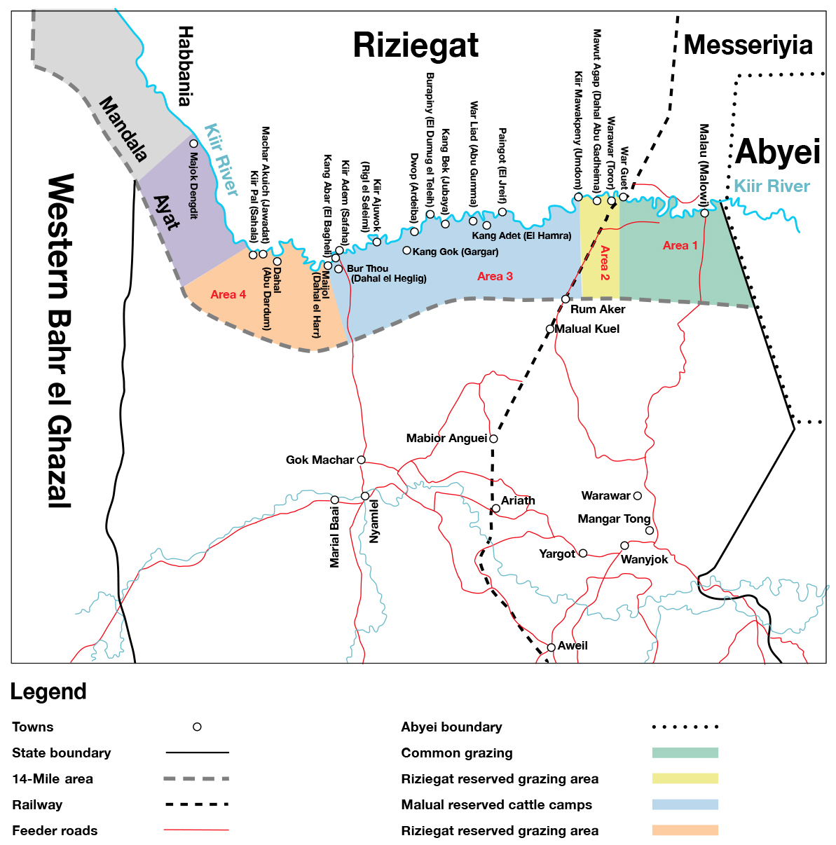
The 14-Mile Area is a strip of wetland in South Sudan’s Northern Bahr el Ghazel State. The area lies along the international border of South Sudan with Sudan to the north-west. As elucidated in section 2.2 below, the area is known to be a grazing point that was used historically by Sudanese nomads looking for green pastures. While Malual Dinka remain original owners of this piece of land, agreements signed during colonial times distorted traditional arrangements permitting Sudanese nomads to access the wetlands. This created tensions which were exacerbated by decades of wars between the north and south of the Sudan.
On independence of South Sudan in 2011, large swathes of land remained disputed, including borderlines passing adjacent to the 14-Mile Area. The border disputes led to brief and sporadic military confrontations between armies of Sudan and South Sudan. The conflict led to mediation by the AU which proposed a buffer zone to defuse tensions and reduce instances of war. Consequently, the area was erroneously included under the signed Cooperation Agreements thus creating further confusion and sparking intense tensions among communities across the borders. The conflicting communities –Malual Dinka and Rizigat – used to manage the area as a soft border crossing but this was no longer the case after the two governments politicised and securitised the area (Rolandsen 2013). The two communities have long-standing traditional border management initiatives practised through annual peace dialogue conferences, conflict management committees and informal channels of communication which address any communal conflicts (Johnson 2009).
History of the 14-Mile Area
The Malual Dinka of Northern Bahr el Ghazal State have fallen victims to a series of Sudanese government barbaric attacks, conquests, and abductions. The main perpetrators of the state-sponsored violence against Malual Dinka have been the Rizeigat and Misseriya ethnic groups that are currently inhabitants of Western Darfur and Western Kordofan north of the Kiir River. They are Arabised and Islamised pastoralists whose economy depends on livestock and transhumance. They have at times renamed Malual Dinka’s areas and claimed the territories that do not belong to them. Classic examples include their illegal renaming of Kiir Adem river as Bahr el Arab.
Despite historical hostilities that had characterised the bilateral relations between Malual Dinka and Rizeigat, they have developed conventional ways to resolve conflicts arising from common grazing, pasture, and fishing areas. In the absence of the governments, these communities have devised means of paying blood compensation for the victims of conflicts. This relationship dates back to the beginning of the 19th century (Majak 1991:73-83).
The Rizeigat movements from the south of the Darfur region to the water lands in the current 14-Mile strip were motivated by two factors. First, they wanted to evade taxes and the dominance of the Sultan of Dar al Fur whose governance was well established around the central authority. Second, they moved to the south of Kiir Adem which belongs to the Malual Dinka of today’s northern Bahr el Ghazal State of South Sudan (Johnson 2010), in order to enjoy sufficient water and pasture for their livestock and hunting, including of elephant tusks. Yet, it was understood that the Malual Dinka’s generous tradition of sharing water and grazing resources with Rizeigat and other Sudanese ethnic groups does not establish right of claim to the land.
The Malual Dinka have always shown hospitality to the Rizeigat as evidenced in 1873 when the latter fled slave traders led by Zubayr Rahma Al Mansur and forced relocation to Umm Duman by Khalifa after the death of politico-religious leader Al Mahdi in 1885. The same happened in 1898 when Sultan Ali Dinar Zacharia of Fur punished Rizeigat for failing to remit taxes. Subsequently, Malual Dinka hosted them (Majak 1991). During these seasonal migrations for pastures and water, the Rizeigat would move to the Kiir River with the permission of Malual Dinka (Majak 1991). The advent of Anglo-Egyptian rule, however, affected relations between Malual Dinka and Rizeigat. Communal clashes became sporadic in latter centuries and even after independence in July 2011, with relations remaining tenuous. Nonetheless, Rizeigat continued to access water resources and green pastures, as neighbours of Malual Dinka.
Historical origins of the confusion over the 14-Mile Area
The Anglo-Egyptian Condominium (1899–1956) rule gradually established ethnic administrative areas that came to be internal borders of an independent Sudan and what are allegedly contested boundaries between the two Sudans. In 1918, the Provincial Commissioner Colonel Savile with his administrators in Dar al Fur unilaterally decided to demarcate the area south to the former Darfur Sultanate covering 40 miles southward as part of Darfur Province in direct contempt of the Provincial Commissioners of Bahr el Ghazal and Equatoria (Wol 2021). This became known as the Savile–Burges–Watson Agreement. The agreement did not consider the native Malual Dinka’s consent, despite obvious resistance. This decision was detested by the Governor of Equatoria Province who understood the position of the Malual Dinka and decided to object to the extension of the right of Rizeigat to the southern region of the Kiir Adem to the disquiet of the civil authorities in Northern Sudan. Given the objection and the then rising rebellion by the Malual Dinka against the award of their land to Rizeigat, the authorities heeded the advice of the Governor of Equatoria Province and revisited the monolithic agreement in 1924 under the Munro–Wheatley Agreement (MWA). It capped the 40-mile area to what is now known as the 14-mile Area (Wol 2021). Therefore, it was the colonial administrators and the Rizeigat who shared a position to which they purport the Malual Dinka consented.
Although Wol (2021) argued that the rationale behind recapping the distance from 40 to 14-Miles was unclear, the report of the Assistant District Commissioner of Baggara in 1926 cited the military rebellion led by spiritual leader Bol Yel dubbed Ariathdit, as one of the reasons. Wol elaborates:
Another important factor behind the creation of the 14-Mile strip was to provide protection for the cattle of the Rizeigat. These were major contributors to the national economy, and generated revenue for the government through the export of considerable numbers, according to a letter by the Equatoria Governor (1939a). Even though rich in terms of the cattle they owned, the Dinka have a cow culture, that is against the economic utilisation of cattle for individual or national well-being. For the Dinka, cattle are mainly used for social and cultural pride and prestige. The colonial authorities, with the mindset of exploiting the country’s resources, did not have any interest in respecting the Dinka cow culture. As such, providing protection for the cattle of the Dinka was not a priority when the agreement was drawn up (Wol 2021:13–14).
Evidently, Wol vividly explains that the meeting that gave rise to the Munro–Wheatley Agreement was attended by the colonial administrators of the Northern Bahr el Ghazal and Raja, the neighbouring district whose land was also contested. However, this meeting was insignificant in determining the course of the resolution. He further explains:
tribal representatives from two communities were invited. Akot Autiak, Lual Dau Marac, Anyoun Aturjong and Diing Wol represented the Malual Dinka tribe, while the Rizeigat tribe was represented by Ibrahim Musa, Yahia Musa and Amir al Mominin. The meeting, which took place at Safaha/Adem on 22 April 1924, proposed that Kiir/Bahr al-Arab and the approximately 14 miles south of the river be considered as Rizeigat territory. The proposal was out-rightly rejected by the Malual Dinka representatives (Wol 2021:14).
The traditional chiefs present were under duress while attending the 1924 MWA since the premise of discussions were vehemently opposed by the Malual Dinka. It could be true that the chiefs were swindled into consenting to the dubious agreement, while the colonial administrators had one thing in mind, which is protecting allies’ cattle against the rebellious Malual Dinka. The meeting, however, did not muster the consent of the Malual Dinka for ceding their land. Unfortunately, a challenge in determining the actual borderline along the area was contested in the aftermath of the April 2012 post-independence conflict between Sudan and South Sudan. This is a consequence of historical favour to Rizeigat against their counterparts in the south of Kiir Adem, which has become part of the sovereign state. (Johnson 2010) succinctly captures this transposition:
The border is supposed to mark the boundary between the territory of the Rizeigat Arabs of Darfur and the Malual Dinka of Bahr el-Ghazal. In 1912 this boundary was set at Bahr el-Arab, but in 1918 it was moved forty miles south of the river. In 1924 this line (the Munro–Wheatley Line) was reduced and readjusted to fourteen miles south. At some point, the grazing boundary became the provincial boundary (Johnson 2007:11).
By all accounts, evidence points to Malual Dinka as the rightful owners and the early settlers of the disputed river (Christopher et al. 2013). According to Johnson (2010:41), Malual Dinka stretched north of Kiir Adem, only to be pushed back when the slave trade reached the area in 1860. They were pushed southward in part because of the military might of the invaders. The Malual Dinka, however, defeated Mahdi in 1893 and their Rizeigat allies, thereby preventing them from grazing south of Kiir in the early 20th century (Majak 1991).
The 1955 Southern Sudan map (see below) delineated the extent of the 14-Mile Area south of Kiir Adem and the swathe of land extending southward, which became known as Safaha, a key settlement along the Kiir River (Johnson 2007:3). Waar Guet (River Guet) which is an extension of Kiir Adem to the east is under the Abiem section of Northern Bhar el Ghazal (Johnson 2010; Wol 2021). The western part of Kiir Adem extends to Ayat which borders the Habbania tribe of Western Darfur. So, the 14-Mile Area lies strictly south of Kiir Adem with Marial Baai to the west and Waar Guet to the east and runs congruent with Kiir Adem. It is argued that efforts to demarcate the west–east borders of the 14-Mile strip were rejected by the colonial administrators, but instead the 1935 Agreement among the colonial administrators favoured the Rizeigat to establish more restrictions on the grazing and watering area within the 14-Mile Area (Christopher et al 2013). This Safaha Agreement was subsequently rejected by Malual Dinka, and they never adhered to the designated wuöt (cattle camping areas) (Wol 2021). The map below succinctly delineates the 14-Mile Area as indicated above.
Recent developments introduced by the Cooperation Agreement
On the secession of South Sudan as a sovereign state, the impending post-Comprehensive Peace Agreement (CPA) issues started to sever relations between the two nations and the need to resolve them became a matter of urgency in normalising the relations between the two countries. In January 2012, the Government of the Republic of South Sudan shut down oil production, denying the Government of Sudan vast revenues in oil transit and other miscellaneous fees. The disagreement triggered the military confrontation in the oil-rich Panthou and surrounding areas from February to April 2012, while also affecting South Sudan’s economy, including a loss of revenue, and creating macroeconomic imbalances (Garang 2021).
This dispute turned out to be among many contentious areas, including the movement of people and was the basis for the Cooperation Agreement. Consequently, the Government of South Sudan published an administrative map on 11 May 2012, much to the disquiet of the Government of Sudan. Such an administrative map would later become the basis for the security arrangement along the borders between the two countries. The following sections discuss the legal, peace, and economic implications of several past events, particularly the Cooperation Agreement.
Implications of designating the 14-Mile Area in the Cooperation Agreement
Political and security implications of the 14-Mile Area for the two countries
Designating the 14-Mile Area as a disputed border goes against the traditional treaties between the Malual Dinka and Rizeigat communities. This has political and security implications for the two countries, their people, and regional peace and security, unless care is taken to resolve it more amicably and equitably. The Cooperation Agreement opened a security Pandora’s box relating to the underlying grievances that had existed for centuries. This includes the fact that the Malual Dinka may not wish to allow passage of Rizeigat cattle down to the south of Kiir Adem. As the protests staged by the Malual Dinka showed at the time, the erroneous designation of the 14-Mile Area has irreversible ramifications for the relations of the Rizeigat and Malual Dinka.
This could trigger a vicious conflict between communities living in the area. From a security perspective, designating the 14-Mile Area as a contested border area is a security threat to Malual Dinka communities living closer to the designated area. Vacating the area as agreed in the 2012 Cooperation Agreement to create a demilitarised buffer zone gives a window of opportunity to illicit transborder activities that are a security threat to the residents of Northern Bhar el Ghazal State, and South Sudan by extension.
For instance, from 4 January to 13 March 2022, Misseriya attacked villages of the Yith Pabol and Mathiang Laac in Aweil East (Spencer 2022:7). The situation at the borders remains dire although Rizeigat and other nomads still have unfettered but negotiated access to pasture around the 14-Mile Area and beyond. The abduction of women and children, raiding of cattle and villages, and raping of women fetching water and firewood at nearby bushes continue to be sources of insecurity for locals in the area. The decision to earmark the area as a contested border zone in accordance with the Cooperation Agreement has consequently exacerbated the Rizeigat militant attacks against the vulnerable communities south of Kiir Adem.
Irrelevance and unsustainability of colonial agreements over the 14-Mile Area
The so-called Savile-Burges-Waton Agreement-SBWA (1918) and Munro-Wheatley Agreement MWA (1924) remain irrelevant despite imposing the grazing rights of the Rizeigat on the 14-Mile Area. They were irrelevant then and are now and will be in the future if they are used as the basis for border demarcation. Consequently, the applicability of the imposed agreements by the occupying administrations did not get recognition from the Malual Dinka people who felt their land had been given away unjustly without their consent.
In light of the radical changes and the independence of South Sudan necessitating an international boundary, any colonial agreements, and especially those done under duress, have become irrelevant. Although the Rizeigat and the Malual Dinka meet annually in the Northern Bahr el Ghazal State, the practice is unsustainable, and there is no reason for continuing it under different governments. It is, therefore, reasonably impracticable given the political, cultural, and religious distinctions between the Rizeigat and Malual Dinka. After all, when the South Sudanese voted on 9 January 2011 in a widely monitored referendum, the voice calling for secession was resounding: an outcome of 98.8 per cent in favour (European Union 2011). The public communicated a message of wanting to be free from oppression, perennial cattle raids, child abductions, and they also wanted their resources protected and to live dignified lives in a sovereign country. Their decision to secede was informed by those aspirations, rendering the colonial monologue treaties irrelevant and unsuitable – just as in the 19th century.
Legal implications of the 14-Mile Area under the Cooperation Agreement
The Cooperation Agreement does not establish a legal basis for the 14-Mile Area
As the historical documents discussed above reveal, there can be no presumptive legal basis for the Cooperation Agreement as a border demarcation. It was simply meant to enhance economic and political cooperation between the two Sudans, with its preamble stating that:
[t]hese agreements [cooperation agreements] are milestones for normalisation of relations and lay foundation for attaining [a] common vision of two viable, peaceful, friendly, and stable states (Preamble to the Cooperation Agreement 2012:2).
In pursuit of friendly relations and the building of two viable states, article 2(1) of the Cooperation Agreement further states that “the parties affirm their commitments to respect the principles of the African Union Constitutive Act and United Nations Charter respecting each other’s sovereignty and territorial integrity.” Furthermore, Article 2(2) of the same document outlines agreements signed – including the Safe Border Demilitarised Zone as being for only “common security.” Evidently, the inclusion of the 14-Mile Area under the Cooperation Agreement could only have been to enhance security and peace between the two countries. It is not and cannot be for determining the legal ownership of the area in terms of international border demarcation between the two countries.
Therefore, nothing in the Cooperation Agreement establishes a legal basis for border delimitation nor land ownership by the Sudan. Its implementation has, however, created a different impression that the movement of the South Sudan People’s Defence Forces 14 miles backwards from the position they were in before the signing of the Cooperation Agreement might mean that South Sudan has given up sovereignty over the area. This impression sparked protests and tensions in 2012 by the people all over South Sudan, including in Aweil. Writing early on during the heat of the moment when the Cooperation Agreement had just been signed, Garang Kuot had this to say:
[e]ither way, the inclusion of “14-Miles” on Cooperation Agreement was such a mistake and doesn’t serve the purpose for which the Cooperation Agreement was signed. I hope Rizeigat and Messiriya communities should not be fooled to begin thinking that they have any territorial claim in Northern Bahr El Ghazal territories because they have no long-term interest in such claims (Kuot 2012).
Clearly, any impression to the effect that the Cooperation Agreement confers legal rights over the 14-Mile Area would be contrary to what the Malual Dinka rightly considers to be the true position. Such false impression might heighten tensions between the two communities. This is to say the 14-Mile Area is not a disputed border point and could not have been properly included under the Cooperation Agreement. For the foregoing reasons and given the unequivocal protest by the people, it serves as a rejection of the claim by any party to apply the Cooperation Agreement in the matter of the 14-Mile Area.
The 14-Mile Area is not terra nullius
The border areas between Sudan and South Sudan had inhabitants even before the coming of the European settlers, nomads, and slave traders (Wol 2021:9-12). As has been set out in section 3 above, the 14-Mile Area is not a no-man’s land. It belongs to the Malual Dinka of Northern Bhar el Ghazal State. Nomads crossing in from Sudan to access the area for green pastures and water does not create a legal right of ownership. That explains why the so-called Munro–Wheatley and Savile–Burges–Watson Agreements focused on shared access to water resources for both communities.
Economic implications of the 14-Mile Area
The irrelevance of the Cooperation Agreement as a determinant of the 14-Mile Area
The Cooperation Agreement between the Sudan and South Sudan, signed on 27 September 2012, recognises the principles underpinning the viability of the two states, and outlines shared interests, including common heritage (Cooperation Agreement 2012:1-7). It should be noted that the Agreement’s nine frameworks cover issues that should have been excluded. The parties should have confined themselves to the economic and related issues, including those relating to oil production, processing, and transit fees (Mayik & Ochi 2021), associated public assets, liabilities, and central bank matters. Those falling in what we regard as the permissible zone also include post-secession issues, including public pensions and a mutual treatment of nationals, and with a focus on the four freedoms: movement, residence, economic activities, and property ownership (Akongdit & Mohamed 2013).
The Agreement actually boasts of many failures. First, it ties the hands of South Sudan by fixing the Transitional Financial Arrangements (TFA) payments in absolute numbers without regard to the inherent volatility associated with global oil prices. It assumes that the prices would stay close to the $ 100 mark, an assumption that soon disappointed when oil prices slumped in 2014 (Badel & McGillicuddy 2015). The Agreement also fails to hold countries accountable for allegedly harbouring rebels in each other’s territory, so generating heated counter-accusations between the Sudan Armed Forces (SAF) and Sudan Peoples’ Liberation Army (SPLA; Jok 2012; Yousif & Rothbart 2012). Finally, the third failure arises from the ill-defined scope. It goes beyond its mandate to cover border issues in passing. The following passage from the Cooperation Agreement on border issues succinctly drives home this salient point:
The Parties agree that the SDBZ will be operationalized in accordance with the administrative and security map presented to the Parties by the AUHIP in November 2011, with additional special arrangements for the operationalization of the SDBZ in the 14-Mile area, maintaining the status quo of the joint tribal mechanism for the dispute resolution (Cooperation Agreement on Security Arrangement 2012:4–7).
Judging from the above quote, the Cooperation Agreement erroneously classifies the 14-Mile Area as disputed between the two countries and deserving demilitarisation and a joint border commission (Garang 2013:8). From the perspective of Malual Dinka, the 14-Mile Area serves only as part of grazing arrangements made with nomadic groups in Sudan. From the authoritative account of Wol (2021), the 14-Mile Area represents a small strip of land located at the Kiir River. While the British colonial administrators designated this strip of land as a pastoralist corridor for Arab nomads in Darfur, especially the in 1924. It is believed that the Rizeigat erroneously based their claim on the 14-Mile Area on their continued access to and use of pasture and water resources in the impugned corridor. This act was seen as a ploy to annex it to Darfur, with Malual Dinka thus remonstrating vehemently against it. Therefore, the framers of the Cooperation Agreement should have known better and should have resisted the unjustified inclusion.
The Cooperation Agreement risks turning 14-Mile Area into a common resource
While the Agreement expresses optimism that the 14-mile Area would act as a soft border and emerge as a safer zone to facilitate cross-border trade, investments, and support subsistence trade, the contrary has happened. By sanctioning the previous erroneous decisions and considering the land as disputed, the 14-Mile Area was turned into the tragedy of the commons, with implications for social mobility, investments, and resource management in the area.
The concept underpinning the tragedy of the commons by American ecologist Garret Hardin, originated in 1968. The original notion describes a situation where shared resources, on average, are overused and overexploited, so leading to depletion and raising risks (Berkes 1985). To prevent risks of depletion, Hardin proposes a need to impose restrictions, including in the use, to curtail the tragedy befalling everyone. Broadly, “Hardin’s Tragedy of the Commons model predicts the eventual overexploitation or degradation of all resources used in common” (Feeny, Berkes, McCay & Acheson 1990:1). In this regard, the tragedy of the commons suggests common ownership and leads to overuse, which is not in the best interests of everyone. Overexploitation, therefore, underscores the consequences of undefined property rights.
Defining property rights of the 14-Mile Area and enhancing trade and investments
Given that the Agreement turned the 14-Mile Area into the tragedy of the commons, there is merit in imposing restrictions on the amount of usage, for example, to attaching property rights. It has long been established that private, state, and communal property rights are among resource management options (Feeny et al. 1990). Users of a common resource can address inherent challenges by communicating and developing rules which limit the use of shared resources. The common example is the issuance of tradable quotas to reduce overfishing in the oceans or erecting tolls to moderate traffic congestion in metropolises.
Three things can be done to define property rights in the 14-Mile Area land which belongs to South Sudan as a communal property. First, the local authorities must promote beneficial investments, including in productive capacity. Drilling boreholes, building roads, and planting trees, for instance, can cement communal ownership rights. According to Oxford Analytica (2021:1), the prevalence of poor transport infrastructure between the two countries would continue to constrain cross-border integration, with wider border demarcation remaining unresolved.
Second, information about the true owners of the land needs to be enhanced. Many people do not know that these tribal arrangements were made without consent from the landowners in the 1920s. The Government of South Sudan should take the lead in reducing information asymmetry between the local people (Malual Dinka) and Arab nomads. The fact that people can choose to be rationally ignorant means they are at risk of relying on misinformation from others which leaves them vulnerable to manipulation (see Akerlof 1978). It must be noted that rational decision-making depends on the quality of information available and on making optimal or suboptimal outcomes a function of information, although there is a cost to acquiring information (Bartlett 2010).
Decisions are usually made at the margins, especially where the marginal value of information is equal to the cost of acquiring information. Anything beyond that point would be irrational. We can pay someone more knowledgeable than us to make important decisions. When we feel chest pains, it is too late to apply to medical school; rather we turn to experts and pay them for medical services. We are, therefore, rationally ignorant and can get information from others for a fee. To further resolve informational issues, a centre can be set up to provide information on or about the 14-Mile Area. There is a presumption that the local administrators can invest in educating the public here.
Finally, both countries need to encourage productive cross-border trade, while acknowledging the true landowners. One of the first principles in economics is the recognition of gains from mutual trade, especially where specialisation based on comparative advantage can improve welfare or Pareto optimal in that sense. Some form of barter trade used to exist between the border communities through the late 1980s. Our mothers, for example, used to exchange grains or sorghum for milk from transhumance Falata women. It was peaceful, convenient, and impactful.
Policy recommendations to promote trade, peace, and security along border areas
The 14-Mile Area should be left to the management of traditional communities
The two governments should leave the management of the 14-Mile Area to traditional communities while establishing a joint border police to oversee the transhumance across the borders. This does not water down international borders between the two countries. They might agree but recognise the 14-Mile Area as part of South Sudan. The Rizeigat will still be permitted to graze southward of Kiir Adem in the Malual Dinka areas, as long as they are unarmed. The existing dispute-resolution mechanisms between the two communities should be strengthened and reinforced by the two governments.
For borders that are not officially well defined, there is always a conflict with huge cost implications. This calls for sharper policy analysis to identify tradeoffs and motivate incentives. Therefore, knowing that the land belongs to the community, the Malual Dinka can impose certain restrictions and adopt a resource management approach to address sustainability and security issues. They can appropriately regulate use, levy fees and spur investments, while realising communal mutual benefits.
Policy options
The paper proposes five broad policy options, restricting movement, paying to play, and expunging the 14-Mile Area from the Agreement, as follows:
Foster community peace initiatives
Both governments must continue to foster community-to-community peace initiatives on clear and unequivocal terms to sustain existing peace and to improve security. This has implications for avoiding the perception that permitting Rizeigat to access water and green pastures in the 14-Mile Area does not confer any legal right of ownership. Eliminating such impressions on the minds and hearts of Arab nomads has the potential to foster peaceful co-existence with the Malual Dinka community.
Respect the territorial integrity of each country
In a situation where the two countries agree to uphold their respective territorial integrity, then the secondary rights to Rizeigat-Baggara by the colonial administration are terminated and impose the sanctity of the international boundary with all its implications. The 14-Mile Area must be strictly limited to the area between Kiir Pal west of Kiir Adem and Waar Guet east of Kiir Adem.
Pay to play in the 14-Mile Area
To encourage investments, mutual cooperation on security ramifications, and to ensure sustainable use, nomads must know that there is no such thing as a free lunch. Therefore, requiring pastoralists to pay to play would incentivise efficient resource use in the area. This strategy could entail small uniform fees for all pastoralists and could be managed by a centralised body – call it the Aweil 14-Mile Area Authority (AMAA). It can use the fees to invest in the area, including paying tour guides, with the intention to educate the public about the landownership, and investing in infrastructure, including roads.
Regulate movement in and around the 14-Mile Area
Entry can also be regulated by designing incentives to shape the behaviour of the Arab nomads. This includes allowing those with good behaviour to graze or requiring others to pay higher fees to enter the area. If some pastoralists refuse to pay to play, they can be barred from using the area. The administration of these schemes should fall on the shoulders of the AMAA. Properly managing this common resource will shape the behaviour of the nomads from the Sudan. Whenever we establish a right or rule and enforce it, we automatically define incentives and regulate people’s behaviour.
Expunge the 14-Mile Area from the Cooperation Agreement
When the countries conduct border demarcation, the 14-Mile Area should not be included. If there are any claims to the area, the Cooperation Agreement is not a competent framework to settle them. The community-to-community dialogue is recommended given that the Arab nomads are interested in and may be entitled to the green pastures and water found in the 14-Mile Area. This approach would promote peaceful co-existence, security, and trade between the two countries. The attempts made by United Nations Interim Security Force for Abyei (UNISFA) in 2021 to impose the zero line for the SDBZ between South Sudan and Sudan at the 14-Mile Area created communal tensions recently and was met with protests , including demands by Malual Dinka that UNISFA should immediately leave the area .
Conclusion
This article discussed the legal, security, and economic implications of designating the 14-Mile Area under the Cooperation Agreement. It argued that the Cooperation Agreement was aimed at enhancing friendly relations and fostering the economic viability of the states. It also maintains that any future resolution to demarcate borders should not deem the 14-Mile Area as disputed land. Rather, local arrangements would continue, allowing Arab nomads access only to greener pastures and water for their animals.
To the best of our knowledge, this is the first paper to examine legal, security, and economic implications relating to the erroneous decision made years ago to include the 14-Mile Area in the Cooperation Agreement. In examining the existing literature, the paper concludes that communal management of a given common resource and investing in the area remain paramount for providing resources and shared benefits to the community. In this context, it contributes to the literature by examining the implications of the inclusion of the 14-Mile Area in the Cooperation Agreement while arriving at policy recommendations designed to ensure community resource management and related investments in the area, thereby advancing the broad objectives of regional peace and stability.
The paper proposes a need to leave the management of the 14-Mile Area to the traditional communities, while supporting mutual trade, investments, and avoiding any attempts to include it in any future border negotiations. It also urges the local authorities to set up an AMAA to manage this resource through collecting relevant fees, providing tour guides, investing in productive capacity, and regulating entry into the area.
There are two major limitations in this study that could be addressed in future research. First, the study focused on a desk review of the available literature. Future research could combine this with fieldwork, including interviewing key informants from both areas – in South Sudan (especially area experts in Aweil and Juba) and Sudan. Second, future work could also conduct a needs-based assessment to ascertain areas where critical investments could be made.
Acknowledgements
We are thankful to many colleagues, both in government and academia, who have provided useful comments on earlier drafts of this article. We also appreciate the peer reviewers for their invaluable comments which strengthen the quality of the article. That said, the usual disclaimers apply, and any errors are those of the authors.
* Mr. Garang Yach James holds a Master of Science in security sector management and a Master of Arts in political philosophy. He is a lecturer of political philosophy at the University of Juba and is currently a Ph.D. student in security and strategic studies with a focus on human security at the University of Juba, South Sudan.
* Dr James Alic Garang holds a Ph.D. in economics. He is the former Deputy Dean of the Faculty of Economic and Social Studies at the Upper Nile University and a senior economist with the Ebony Center for Strategic Studies. He is currently a senior advisor to the executive director at the IMF Executive Board in Washington, DC.
* Dr Joseph Geng Akech holds a Doctor of Laws (LL.D) in comparative constitutional law. He is an adjunct assistant Professor of Law at the University of Juba and an independent researcher in constitutional designs, governance, transitional justice, and human rights.
References
Akerlof, George 1978. The market for “lemons”: Quality uncertainty and the market mechanism. In: Uncertainty in economics. Berkeley, CA, Academic Press, pp. 235–251.
Akongdit, Addis and Issam Mohamed 2013. Cooperation agreements between Sudan and South Sudan and prospect of economic and political stability. Khartoum, Al-Neelain University, Economics Department. Available from: https://papers.ssrn.com/sol3/papers.cfm?abstract_id=2206890 [Accessed 13 June 2022].
Badel, Alejandro and Joseph McGillicuddy 2015. Oil prices: Is supply or demand behind the slump? Economic Synopses, (8), pp 1-2. St. Louis, MO, Federal Reserve Bank of St. Louis.
Bartlett, Randall 2010. Thinking like an economist: A guide to rational decision making. Chantilly, VA, Teaching Company.
Berkes, Feeny 1985. Fishermen and ‘the tragedy of the commons.’ Environmental Conservation, 12 (3), pp.199–206.
Cooperation Agreement 2012. Preamble to the Cooperation Agreement between the Republic of the Sudan and the Republic of South Sudan, 2012.
European Union Election Observation Mission 2011. Southern Sudan Referendum Final Report, 9–15 January 2011.
Feeny, David, Fikret Berkes, Bonnie McCay and James Acheson 1990. The tragedy of the commons: Twenty-two years later. Human Ecology, 18(1), pp. 1–19.
Garang, James Alic 2013. The question of big government, and financial viability: The case of South Sudan. Sudd Institute Policy Brief, 1 February.
Garang, James Alic 2021. Agency creation as an instrument of rent-seeking in South Sudan. International Journal of Economic Policy in Emerging Economies, 14 (4), pp. 360–376.
Johnson, Douglas H. 2009. Southern Sudan Boundaries: Background Paper. Available from http://hdl.handle.net/10427/78286 [Accessed 14 June 2022]
Johnson, Douglas H. 2009. Decolonising the borders in Sudan: Ethnic territories and national development. Empire, development and colonialism: the past in the present, pp. 176–187. Available from: 2009_Johnson_Decolonising_Borders-with-cover-page-v2.pdf (d1wqtxts1xzle7.cloudfront.net)
Johnson, Douglas H. 2010. When boundaries become borders: The impact of boundary-making in Southern Sudan’s frontier zones. Nairobi, Kenya, Rift Valley Institute.
Jok, Madut Jok 2012. Contextualizing the cooperation agreements between the two Sudans. The Sudd Institute Policy Brief No. 2.
Kuot, Garang Kuot 2012. 14 Miles: Potential implications and scenarios. Sudan Tribune, 30 October. Available from: https://sudantribune.com/article43663/ [Accessed 18 May 2022].
Majak, Damazo Dut 1991. The Malual Dinka–Baqqara border conflict and the impact on national integration in the Sudan. Northeast African Studies, 13 (1), pp. 73–83. Available from: https://www.jstor.org/stable/43660338 [Accessed 17 May 2022].
Mayik, Bithou and Erneo Ochi 2020. The issue of oil and disputed areas in the conflicts between Sudan and South Sudan. Journal of Global Peace and Conflict, 8 (2), pp. 12–18.
Mulla, R 2018. Federalism with particular emphasis to South Sudan. Kampala, Uganda, Fountain Publishers.
Oxford Analytica 2021. Sudan–South Sudan conflict in Abyei may remain frozen. Emerald Expert Briefings, (oxan-db).
Rolandsen, Øystein H 2013. Too much water under the bridge: Internationalization of the Sudan–South Sudan border and local demands for its regulation. In Christopher Vaughan, Mareike Schomerus, & Lotje Vries (ed): The Borderlands of South Sudan. New York, NY, Palgrave Macmillan. pp. 23–43.
Spencer, Robert 2022. South Sudan: Muslims murder 28 people, burn down 57 houses, in Jihad attack on Christian community, Sudan Tribune, 14 January. Available from: https://robertspencer.org/2022/01/south-sudan-muslims-murder-28-people-burn-down-57-houses-in-jihad-attack-on-christian-community [Accessed 7 June 2022].
Vaughan, Christopher, Mareike Schomerus and Lotje Vries 2013. The Borderlands of South Sudan: Authority and identity in contemporary and historical perspectives. New York, NY, Palgrave Macmillan.
Wol, Dhieu Mathok Diing 2021. Pastoralism, boundaries, and disputes: Administration and conflict management in the 14-Mile. ACCORD Occasional Paper Series 1, pp 1–65.
Yousif, Adeeb and Daniel Rothbart 2012. Sudan and South Sudan: Post-separation challenges. Beyond Intractability Collaborative, December 2012. Available from: https://www.beyondintractability.org/casestudy/yousif-rothbart-sudan-south-sudan [Accessed 7 June 2022].